
|
|
||||||||||||||||||


| 2026-2027 Electoral Calendar, latest official version |

|
 |
|
|
|
|
|
|
|||||||
|
|
Haiti - ELSA : Haiti in Red Vigilance
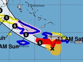
At 11am, the center of Tropical Storm Elsa was located near latitude 17.0 North, longitude 71.6 West, 166 South-East of Jacmel, 110km South of Pedernales (Dominican Republic), Elsa is moving toward the west-northwest near 29 mph (46 km/h). A decreasein forward speed is expected later today and Sunday, followed by a turn toward the northwest Sunday night or Monday. On the forecast track, Elsa will move near the southern coast of Hispaniola latertoday and tonight, and move near Jamaica and portions of easternCuba on Sunday. By Monday, Elsa is expected to move across centraland western Cuba and head toward the Florida Straits. Elsa is forecast to move move near or over portions of the west coast of Florida on Tuesday. Reports from an Air Force Reserve Hurricane Hunter aircraft indicate that maximum sustained winds are now near 70 mph (110 km/h) with higher gusts. Little change in strength is forecast tonight, but gradual weakening is forecast on Sunday and Monday when Elsa is expected to be near or over Cuba. Tropical-storm-force winds extend outward up to 125 miles (205 km) mainly to the north of the center. Haiti : Forecasts of strong cumulative rainfall of up to 100 to 150 mm in the plains, or even 200 mm on the heights of the Selle, Hotte and Montagnes de la Gonâve massif, Strong wind gusts ranging from 118 to 130 km / h and dangerous sea conditions that can cause severe flooding, flash floods, landslides, mudslides and coastal flooding are possible, especially in the southern part of the country approaching and passing this hurricane system for today. The Meteorological Prediction Center (CPM) of the Hydrometeorological Unit (UHM) in conjunction with the SPGRD and DGPC, OFNAC, AAN and SEMANAH informs the population that flights and boats from or to ports and airports in the southern region of the country are temporarily prohibited until further notice. Also, the General Directorate of Civil Protection and the SPGRD in concert with the UHM maintain this Saturday July 3 at 5 a.m., the activation of the National Risk and Disaster Management Plan with a red Vigilance level (i.e. Risk of Disaster impacts of strong to violent intensities) on the country, in particular on the South-East, the West, the Nippes, the South and the Grande-Anse, asks the Haitian population to be vigilant, to stay at the listening of weather reports from the UHM, advice from the authorities of their respective areas to know the behavior to adopt during the passage of this cyclonic system and to prepare to evacuate in the areas concerned if ever the authorities would have made such a decision during the next few hours. HL/ HaitiLibre
|
|









|
|
Why HaitiLibre ? |
Contact us |
Français
Copyright © 2010 - 2026 Haitilibre.com |