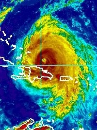
Haiti - Maria : Alert 2 is maintained, be vigilant !
"Alert 2 is maintained, this Thursday, September 21 in the late afternoon, at the level of orange vigilance on the North region," announced the Directorate of Civil Protection (DPC).
Compared to the dangerous sea conditions observed on the northern coast of the country, SEMANAH reiterates the ban on all cabotage operations on the northern coastal areas until further notice.
The SPGRD in conjunction with UHM and the DPC urges the Haitian population to be cautious.
At 5pm the eye of Hurricane Maria was located near latitude 20.8 North, longitude 69.8 West (275 km north-east of Cap-Haitien). Maria is moving toward the northwest near 9 mph (15 km/h), and this general motion is expected to continue through tonight. A turn toward the north-northwest is forecast early Friday, with that motion continuing through Saturday. On the forecast track, Maria's eye will continue to pass offshore of the northern coast of the Dominican Republic this evening, and then move near or just east of the Turks and Caicos Islands and southeastern Bahamas tonight and on Friday.
"This trajectory keeps Haiti out of the direct effects of this cyclone because the Hurricane winds inside this system blow out over a radius of 95km and storm winds over a radius of 240km. However, of showers thunderstorm associated with it would cause of cases of flooding ranging from moderate to strong over the country, particularly on the departments of the North-East, North, Central and Artibonite. These areas could receive between 100 and 200mm of rain during the passage of this cyclone off the northern coast, not to mention the dangerous sea conditions for the northern coastal areas with waves up to 10 to 14 feet," informs the National Center Meteorology (CNM) of Haiti.