
|
|
||||||||||||||||||


| 2026-2027 Electoral Calendar, latest official version |

|
 |
|
|
|
|
|
|
|||||||
|
|
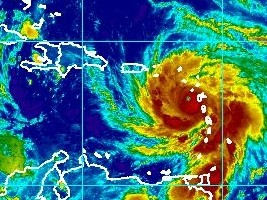
Haiti - FLASH : Hurricane Maria in category 4, Haiti in pre-alert yellow
Tuesday morning 5:00 am, the center of Hurricane MARIA downgraded from Category 5 to Category 4 on the Hurricane Saffir-Simpson wind scale (winds of 210 to 249 km/h) was located near latitude 16.0 North and longitude 62.3 West. MARIA, which has passed the West Indian Arc, is heading west-north-west at 9 mp/h (15 km/h). This trajectory should continue until Wednesday. It will move to the North-East Caribbean Sea today and will approach the Virgin Islands and Puerto Rico tonight and Wednesday. Unless there is a change in its trajectory, MARIA is expected to pass north of Haiti on Thursday and Friday and could have a smaller impact on the country, considering its northward shift. However, it is to be expected heavy swell, torrential rains and powerful gusts devastating over the northern departments. MARIA is a Category 4 hurricane and will fluctuate in intensity over the next 48 hours, but it should remain an extremely dangerous category 4 or 5 hurricane... Hurricane force winds extend up to 30 miles (45 km) from the center and the winds of tropical storms force extend outwardly up to 125 miles (205 km). Yesterday in Port-au-Prince, the Permanent Secretariat of Risk Management (SPGRD) launched the first phase of early warning at the level of yellow vigilance in anticipation of the passage of Maria. The first special bulletin of the Hydro Meteorological Unit of Haiti, foresees that the country could feel the first impacts of the phenomenon Wednesday evening or Thursday, bringing to the northern part of the country threats of floods, landslides and dangerous sea conditions. The SPGRD, together with the Civil Protection Directorate (DPC) and the UHM, is asking the population, in particular the inhabitants of the zones at risk, to prepare and stay tuned to weather reports and safety instructions. See also : SL/ HaitiLibre
|
|









|
|
Why HaitiLibre ? |
Contact us |
Français
Copyright © 2010 - 2026 Haitilibre.com |