
|
|
||||||||||||||||||


| 2026-2027 Electoral Calendar, latest official version |

|
 |
|
|
|
|
|
|
|||||||
|
|
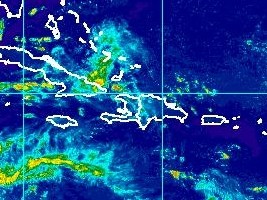
Haiti - FLASH : Transition of a tropical wave, risks of floods
The Haitian Hydro-Meteorological Unit (UHM) informs of the presence of a very humid and unstable mass of air caused by a tropical wave that could influence the weather conditions of Haiti as of Wednesday evening and during the day of Thursday 27 July. As a result, moderate to severe moderate to heavy rain showers are expected throughout the territory, particularly in the Northeast, North, Central, Artibonite, Nippes, South East and West departments. The flood forecasting model indicates a level of soil saturation between 85% and 95% on some watersheds in the Center, Artibonite, North and West departments with flood risk. The passage of the tropical wave could cause locally stormy showers from moderate to strong. Accordingly, the UHM, in conjunction with the National Risk Management and Civil Protection System, requires the inhabitants of areas affected by floods, landslides... of these departments to remain vigilant and scrupulously apply the usual safety precautions during these stormy showers. Subsequent Trends Thursday: Chance of thunderstorms possible over the country, especially in the late afternoon and in the evening at the passage of l'Onde tropicale. Friday: The mass of air remains humid and unstable on the country, showers and thunderstorms expected in the evening. NOTICE cabotage : Northern Coastal Zone : Wednesday & Thursday - East wind: 15-20 knots; - Wave height: 3 to 5 feet; - Little agitated to agitated sea; - Isolated thunderstorms expected; - Caution advised to small boats. Gulf of the Gonâve : Wednesday & Thursday - East wind: 15-20 knots; - Wave height: 3 to 5 feet; - Little agitated to agitated sea; - Caution advised to small boats. Southern coastal zone : Wednesday & Thursday - East wind: 15-20 knots; - Wave height: 6 to 8 feet Wednesday; Becoming 5 to 7 feet on Thursday; - Turbulent sea ; Vigilance is essential for cabotage operations; Small boats should be careful to stay near the coast and avoid venturing broad. HL/ HaitiLibre
|
|









|
|
Why HaitiLibre ? |
Contact us |
Français
Copyright © 2010 - 2026 Haitilibre.com |