
|
|
||||||||||||||||||


| 2026-2027 Electoral Calendar, latest official version |

|
 |
|
|
|
|
|
|
|||||||
|
|
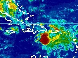
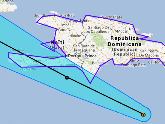
Haiti - Weather : Chantal approaches, Haiti in red
Tropical Storm Chantal, is located this morning at 5:00 am at 16.5N 69.5W, or 223km south of Santo Domingo and 375km southeast of Port-au-Prince, 375km southeast of Jacmel and 397km southeast of Bainet. Chantal moves at a speed of 46km/h towards West North-West, with maximum sustained winds of 75km/h, with higher gusts. Storm winds extend outward up to 150 km from the center. This general motion with a decrease in forward speed is expected in the evening. A turn toward the northwest is expected on Thursday, followed by a turn toward the north-west in the Thursday night. On the forecast track... center will be near or over Hispaniola later today. Near or over eastern Cuba early Thursday... and near the center cuba Thursday night. Rainfall up to 10 inches are possible on Hispaniola says NOAA. Yesterday evening, Haiti, passed to the Alert phase at the level of Vigilance Red, face the threats of storm for all regions of the country compared to the conditions of heavy rain with risk of rockfalls, landslides and flooding from Wednesday evening.
"Tropical Storm Chantal is approaching of the island of Haiti with a slight increase in movement speed which decreases a little intensity. However, forecasting models argue that a cross in could reach the southern coast of the Republic of Haiti [unlike the previous forecast that concerned the northern coast of the country] this Wednesday from 8:00 p.m. This system is likely to generate heavy rains with storm, violent gust, and heavy seas on all parts of the country during its passage," indicates the National Meteorological Center (CNM) of Haiti. The CNM in conjunction with SPGRD and DPC asks the population livinh in risk areas to remain vigilant and strictly implement the following safety instructions : - Shelters (protect) all the important documents. - Build food reserves. - Be very cautious near rivers in case of heavy rains, do not the cross them under no pretext. - During storms and high winds, do not shelter near windows or under the trees. List of flights canceled https://www.haitilibre.com/en/news-8976-haiti-chantal-list-of-flights-canceled.html 11h00 a.m. - Chantal off the south coast but... https://www.haitilibre.com/en/news-8978-haiti-weather-chantal-off-the-south-coast-but.html 5h00 p.m. - Chantal turned into Tropical Wave https://www.haitilibre.com/en/news-8981-haiti-weather-chantal-turned-into-tropical-wave.html HL/ Haitilibre
|
|









|
|
Why HaitiLibre ? |
Contact us |
Français
Copyright © 2010 - 2026 Haitilibre.com |