
|
|
||||||||||||||||||


| 2026-2027 Electoral Calendar, latest official version |

|
 |
|
|
|
|
|
|
|||||||
|
|
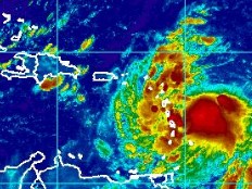
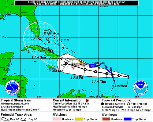
Haiti - Environment : ISAAC en route to Haiti (UPDATE 2h06 pm)
The tropical storm ISAAC is located this morning to 15.5°N 57.3°W, or 1.638 km southeast of Port-au-Prince, and about 430 km east of the arc Caribbean (Guadeloupe, Dominica, Martinique...), is heading to Haiti at a speed of 30km/h westbound, according to forecasts provided by the NHC, the Dominican Republic should began to be affected in the Friday night, around 2 am, and Haiti between Friday afternoon and Saturday 2 am. Currently winds are 75 km/h maximum. The National Meteorological Centre (CNM) in a special bulletin announcing that the SPGRD launched this Tuesday, August 21, 2012 at 10 am an early warning of vigilance yellow (ie impact risk mild to moderate) to heavy rains and heavy seas and announced the activation of the plan PNGRD facing the threats of heavy rain and heavy seas with risks of landslides, mudslides and flooding throughout the country from Thursday night. Update 11h30 am CNM indicates in its latest bulletin that "the tropical storm ISAAC achieves a better organization this morning and could go to hurricane category 1 during the day of Thursday..." while indicating that the tropical wave #24 already left the Mona Passage towards the southern part of the island of Haiti. Convective activities mild to moderate remain possible for the southern regions tonight. Update 2h06 pm he CNM in its special bulletin #3 informs the population that the pre-warning 1 at the level of Red Vigilance (ie risk of impact of intensity violent to extreme) was declared, and recalls the activation of the Plan PNGRD faces to the threats of strong winds, heavy rain and big seas with risk of landslides, mudslides and flooding throughout the country from Friday.
The CNM together with the SPGRD and the DPC asks the population in the areas at risk to remain vigilant and strictly implement the following safety precautions : - Be prepared to evacuate if necessary, areas exposed to floods and landslides (seaside, gullies, rivers, mountain slopes, etc...) - Do not cross rivers in spate under any circumstances. - In case of severe thunderstorms, do not shelter near windows and wooded area. More information to come... S/ HaitiLibre
|
|









|
|
Why HaitiLibre ? |
Contact us |
Français
Copyright © 2010 - 2026 Haitilibre.com |