
|
|
||||||||||||||||||


| 2026-2027 Electoral Calendar, latest official version |

|
 |
|
|
|
|
|
|
|||||||
|
|
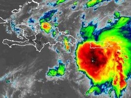
Haiti - Storm Laura : From 10 to 20 cm of rain and strong gusts are expected
With the western trajectory maintained by Tropical Storm Laura, the Island of Haiti risks being impacted by the direct effects of the storm (rains and strong winds). Indeed, the Laura Center is scheduled to return to the Haitian-Dominican border in the evening through the Northeast department and emerges through the Northwest through Artibonite. Currently Laura is located 30 km southwest of Ponce, Puerto Rico and 335 km east southeast of Santo Domingo, Dominican Republic, laura is moving west at nearly 30 km/h (18 mi/h) and a generally west-northwest movement is expected over the next few days. Laura's center is excepted to move near or over Hispaniola this afternoon and tonight, and near or over eastern Cuba on Sunday and Sunday evening. Maximum sustained winds are close to 65 km/h with higher gusts. Slow strengthening is expected over the next few days. Tropical storm force winds extend outward up to 335 km from the center. "The forecasts of heavy torrential precipitation and gusts of very strong winds are maintained on the whole of the National territory. The accumulations of rain can go from 100 to 200mm on certain places mainly in the South-East and the North-West of the country. As a result, of risks of severe flooding, flash floods, landslides, mudslides and dangerous sea conditions are maintained over the country in the interval from tonight to tomorrow afternoon," indicates the Hydro-meteotological Unit (UHM) of Haiti. In relation to the dangerous sea conditions which will be temporarily installed on all Haitian coasts, the SEMANAH in conjunction with the UHM announces the ban on all cabotage operations throughout the national territory until further notice. The SPGRD together with the UHM and the DGPC asks the Haitian population to exercise caution and stay tuned to weather reports from the UHM and also the authorities of their respective areas to know the behavior to adop. on the occasion of the passage of this cyclonic event. Instructions :
Let's recall that Haiti is at the orange vigilance level of the National Risk and Disaster Management Plan (PNGRD). HL/ HaitiLibre
|
|









|
|
Why HaitiLibre ? |
Contact us |
Français
Copyright © 2010 - 2026 Haitilibre.com |