
|
|
||||||||||||||||||


| 2026-2027 Electoral Calendar, latest official version |

|
 |
|
|
|
|
|
|
|||||||
|
|
Haiti - FLASH: Storm Isaias, Haiti on Orange alert
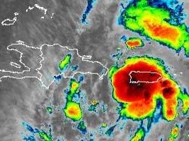
This Thursday, tropical system #9, became a tropical storm named Isaias located at 17.2N 67.9W between the Dominican Republic and Puerto Rico, 440km south-east of Haiti, the winds are 95km/h and the system travels at 33 km/h in a North-West direction. The first effects are starting to be felt on the island with rains and gusty winds. At 5 am, the center of tropical storm Isaias was located near latitude 17.2 North and longitude 67.9 West. Isaias is moving northwest at near 21 mph (33 km/h), and moving from west-northwest to northwest. Some decrease in its movement speed is expected over the next few days. According to forecasts, the center of the storm will move over Hispaniola during the day and near the Southeast of the Bahamas by Friday morning," informs the National Oceanic and Atmospheric Administration (NOAA). Maximum sustained winds are near 95 km/h with higher gusts. Little change in strength is expected until the arrival in the Dominican Republic this Thursday morning at 8:00 am, with strength expected on Friday and Saturday. Tropical storm force winds extend outward as far as 665 km (415 miles) from the center. A Weatherflow station in Yabucoa Tanque de Agua reported sustained winds of 52 mph (83 km/h) with a gust to 59 mph (94 km/h). Tropical storm conditions are expected to reach parts of the Dominican Republic and Haiti in the warning zone on Thursday Estimated rain in northern Haiti : 7 to 15 cm with isolated maximums of up to 20 cm. In addition, Wednesday in Haiti at 9:00 am, the Directorate General of Civil Protection, the Permanent Secretariat for Risk and Disaster Management (SPGRD) in conjunction with the Hydro-Meteorological Unit of Haiti (UHM) announced the activation of the National Risk Management Plan with a Orange Vigilance level (moderate to strong impacts expected within 24 to 36 hours) on the country. Current forecasts call for heavy rains and potentially fatal flash floods and landslides across the country, particularly around the north coast. Humanitarian partners are preparing to respond to potential impacts, under the leadership of the Government of Haiti. SL/ HaitiLibre
|
|









|
|
Why HaitiLibre ? |
Contact us |
Français
Copyright © 2010 - 2026 Haitilibre.com |