
|
|
||||||||||||||||||


| 2026-2027 Electoral Calendar, latest official version |

|
 |
|
|
|
|
|
|
|||||||
|
|
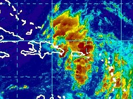
Haiti - Weather : Possibilities of strong perturbations, be vigilant (UPDATE 11:33 am)
Shower and thunderstorm activities associated with a small area of low pressure located north of the Virgin Islands remains disorganized. Interaction of this system with Hispaniola could limit development through tonight. However, environmental conditions are expected to be more conducive for development when the disturbance moves near or over the southeastern Bahamas on Saturday, and a tropical depression or tropical storm is likely to form over the weekend or by early next week. Regardless of tropical cyclone formation, gusty winds and heavy rainfall are expected across portions of the Leeward Islands, Puerto Rico, and the Virgin Islands today, and over Hispaniola and the southeastern Bahamas tonight and Saturday. Those islands should monitor the progress of this disturbance. Cyclone formation chance through 48 hours is high, 60%. Formation chance through 5 days is high, 80%. The north coast of Haiti could be affected. UPDATE 11h33 am For its part, the National Meteorological Center (CNM) of Haiti said this morning "Moist and unstable air at the approach of center of low pressure associated with the tropical wave (OT31) influences the weather of regions of the Greater Antilles this morning. This situation combined with the local effects could generate scattered showers and thunderstorms, including some episodes of winds over the country in the afternoon and evening of today, but the latter should be more intense by Saturday evening with the movement of the system which is expected go along with the extreme east of the Dominican Republic and then rise just north of the island of Haiti at the level of Atlantic. However, the CNM is closely following the evolution of this system to alert people in time if the need arose," adding for the forecast for Haiti "Beautiful weather this morning; Cloud development in the afternoon and evening; Strong sensation of heat during the day, more or less bearable temperatures in the late evening; Showers and isolated mild to moderate planned across the country, including the departments of the North, Centre, Artibonite, West, South and Grande-anse. Friday : Nice weather in day; rain and scattered thunderstorms in the evening; Saturday: Cloudy during the day, scattered thundershowers planned afternoon and evening. » HL/ HaitiLibre
|
|









|
|
Why HaitiLibre ? |
Contact us |
Français
Copyright © 2010 - 2026 Haitilibre.com |